Land Allocation Decision Support System
Agro-meteorological Indicators of Climate Change
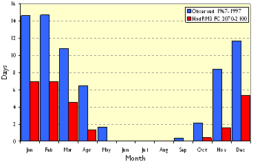
Indicators are pieces of information that can be used by managers to make decisions about the system (e.g. farm, estate, water-catchment, etc) that they manage. Our agro-meteorological indicators (see example chart below) are derived from weather and soils data. We produce two sets of indicators one using observed climate data and one using future climate data. By comparing the outputs we illustrate how things may change in the future.
Climate Data
The Met Office provides us with daily weather data for sites across the UK. In order to make predictions of future patterns of weather we use the results from the Hadley Centre Regional Climate Model (HadRM3).
Soils Data
In order to assess the impact of climate change on soils we have developed a simple Soil Water Budgeting model which uses daily climate data and a set of soil parameters to produce a time series of soil moisture.
Workshop Series
During 2006/07 we ran a series of workshops where we presented the indicators for a particular area of interest. The feedback was used to refine the presentation materials so that they would be more relevant for the agricultural industry. To date we have prepared indicators for several Eastern and Southern areas of Scotland (Aberdeen, Mylnefield, Carnwath, Galashiels, Eskdalemuir, Dumfries and Auchincruive) and are now planning another set of workshops that will cover the West coast, Highlands and Islands.
It is hoped that the materials that we present will help land managers to understand the changes that might occur to the climate and soil so that existing land management systems can be adapted to suit the new conditions. You can download the most recent workshop materials below.
Downloads
- Agro-meteorological Indicators of Climate Change (Galashiels for St Boswells workshop, May 2007)

