Land Allocation Decision Support System
Soil Water Budgeting Model
The LADSS Soil Water Budgeting model attempts to improve upon the model developed by L.P. Smith of the Met Office (MAFF 1967, 1971) and used in Met Office memo 108.
The previous system defined 5 inches (125mm) of water as available for extraction in 3 layers. The first layer of 50mm is available at 100% of the potential evapotranspiration rate. The second layer of 50mm is available at 50% of the rate. The third is available at 25%. No further water can be removed from the soil. Rainfall is added to the topmost layers that are below capacity during refill irrespective of the total soil moisture deficit.
It was noted that the assumed maximum deficit of five inches is likely to be an over estimate in the rough grazing lands; furthermore the major source of error probably lies in the assumption of a five inch maximum. The true value is bound to be a function of soil type and depth (MAFF 1971). The paper acknowledged that the monthly or fortnightly time intervals introduced errors that could be reduced with a finer resolution. The MAFF model did not specify the critical points of soil moisture (i.e. Field Capacity); instead it concentrated only on the available water capacity.
The LADSS model is intended to improve upon the MAFF system thus:
- Varying soil available water according to soil conditions (depth and texture)
- Dynamically set the layer thresholds (maintaining ratios from original model)
- Model soil moisture on a daily time-step
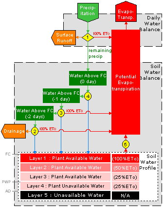
- Model Surplus Water Above FC and (as described in Met Office memo 108) drain any excess after 3 days
- Introduction of a fourth layer below PWP where we can evaporate down to the air dried (AD) point
The model requires inputs such as soil depth and hydraulic properties such as field capacity (FC). From this it derives the water that is available in the soil and the various limits such as permanent wilting point (PWP).
Daily precipitation and reference evapotranspiration (ETo) are also provided to the model. We have implemented the Priestly-Taylor method for estimating ETo.
In the original MAFF model AW was 125mm. Layer 1 (100% ETo) was the first 50mm, layer 2 (50% ETo) was the second 50mm and layer 3 (25% ETo) was 25mm. This gave proportions of 2:2:1. In the new model we vary AW but preserve the proportions from the original model. For example, if AW = 150mm then we would proportion the layers 60mm/60mm/30mm.
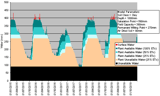
The soil water budget produces a daily profile containing actual evapotranspiration, surplus water, soil water (per layer), runoff and drainage. This allows us to plot soil water conditions in the format shown below.