 LandSFACTS
LandSFACTS model details (inputs/outputs)
The model was originally (v1.6) set up to simulate cropping systems at the landscape scale. Since 2007, it was further developed to allow modelling land uses at multiple scales within an evolving environment. The diagram below presents the main inputs & outputs of the model.
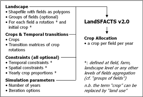
Diagram of LandSFACTS version 2.0 inputs and outputs
Temporal constraints: return period, minimum and maximum repetition of crops within a field, forbidden crop sequences, past allocations. Each constraint can be field specific.
Spatial constraints: yearly land capability, separation distances between crops, linked fields. In progress: connectivity metrics.
Cf. publications and software helpfile for full details.
|
Updated: 23 Jan 2024, Content by: MC
|