 Catchment Management
 The James Hutton Institute
This page is no longer updated. The Macaulay Land Use Research Institute joined forces with SCRI on 1 April 2011 to create The James Hutton Institute.
Allt a' Mharcaidh Catchment
Surface water chemistry
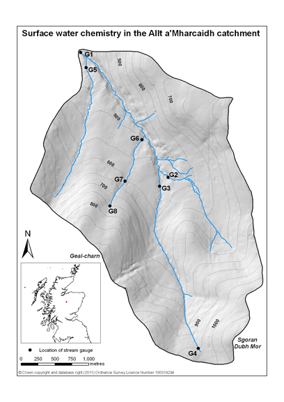 At the catchment outflow, stream temperature, pH, and flow are continuously monitored at the stream gauge site. Since Feb 1994 surface water samples have been collected at weekly intervals from the stream outflow (G1). Two major tributaries (G2 and G3) to the Allt a' Mharcaidh were sampled at weekly intervals during the period February 1994 through to June 1998. A spring effectively forms the source of one of these tributaries and spring water was collected at fortnightly intervals from the site G4 between 1995 and 1998 in a ground water discharge zone at an altitude of 970 m. Surface water sampling resumed in 2004 at gauges 2 and 3 following the commencement of a new RERAD project in the catchment. In addition new gauges were set up at two tributaries lower in the catchment (G5 and G6).
Sampling will continue until 2011. Routine analysis is conducted on all surface water samples (H, pH, Total N, DOC, Al, Na, K, Mg, Ca, PO4-P, NO3-N, NH4-N, SO4-S, Cl, Cu, Zn, Fe, Mn, Si).
To access the data charts click on interactive chart or use the list below:
|
Updated: 23 Jan 2024, Content by: RH
|