|
History and Summary - Snow Cover Depletion Curves - Meteorological Extrapolation, Runoff Generation and Routing - Operational Experience and Research Extensions - Online Documentation - Source Overview This page gives a brief overview of the SRM model's history and key features. Subsequent pages give more details of the parameters required by the SRM model, a simple demonstration of the application of the model to HYDALP basins, and examples of actual trial results obtained by the HYDALP project. The SRM model originated with Jaroslav
Martinec, attached at the time to the Swiss Snow and Avalanche
Research Institute at Davos.
Martinec
(1975) described a snowmelt runoff model which has come to be
referred to as SRM. It has undergone substantial development
since 1975, by Martinec himself in collaboration with Al Rango (US
NASA, later US ARS) and Michael Baumgartner (University of Bern).
The model has been amended and extended several times in the light of
operational experience. The current version, 3.2, is described
by
Martinec
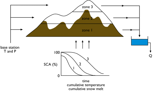
et al. (1994). The basic structure of SRM is shown schematically in Figure 1 below:
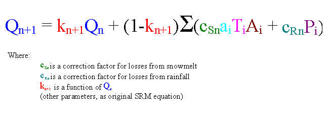
The original version of the model can be represented by a single equation (1):
One other parameter is implicit in the equation above: a temperature lapse rate used to extrapolate Ti from temperature at a base station. The current version of SRM is rather more complicated and contains additional parameters, though the basic structure is unchanged. It can be represented as (equation 2):
The boundary conditions which must be specified before eq. 2 can be applied are the time series of snow covered area (SCA) in each zone. These time series were originally termed snowcover depletion curves (SDCs), though the term conventional depletion curve (CDC) is now used. They can be obtained in several ways. In the original application of the model to the small (43 km2) Dischma basin in eastern Switzerland (Martinec 1975) the CDCs were based on ground observation and aerial photographs for the previous year being simulated. However, the potential contribution of satellite remote sensing was soon recognised. Rango & Martinec (1979) applied SRM to Dinwoody Creek (Wyoming, US; 228 km2) using CDCs interpolated by eye between periodic SCA values measured from Landsat MSS hard-copy imagery. Most subsequent applications have also used satellite remote sensing as the main or sole source of information on snowpack depletion. However, digital image processing has replaced manual analysis of hard copy images, and some applications in large basins have used medium-resolution satellite data sources such as AVHRR (e.g. Baumgartner et al. 1987, 1991) rather than high-resolution sources such as Landsat MSS or TM. The basis of this approach is that 'patterns of disappearing snow cover are similar year after year' (Martinec 1980). However, the CDC for a particular basin and elevation zone can vary from year to year because of differences in the amount of winter snow accumulation, and also because of differences in melting conditions. There is a tendency for early-season SCA to be higher after a snowy winter (this is the basis of the use of regression equations to predict total melt-season runoff from early-season SCA: e.g. Rango et al. 1977), but experience in the Alps (Martinec 1980) and elsewhere shows that the same initial SCA can correspond to different amounts of stored snow. The higher the SWE, the more slowly the SCA will decline under the action of a given temperature series. A family of CDCs might therefore be expected to exist for a particular basin and zone, all similar in shape but with the timing varying according to initial SWE in the year in question. Successful modelling of a particular season using a CDC therefore requires direct observation of the CDC using frequent satellite data in near real time, knowledge from ground observations of basin-average SWE, or selection of the most appropriate CDC from a family of curves derived for previous years. Rango & Martinec (1982), writing before it was possible to consider operational use of frequent EO in near real time and reckoning that good ground data on basin-wide SWE were seldom available, favoured the third approach. One of a family of CDCs could be selected on the basis of SCA from one or two satellite overpasses early in the melt season. The more rapidly SCA declines from its initial value, the lower the initial SWE must have been. They also recognised that the rapidity of decline in SCA must depend on the temperature conditions as well as the initial SWE, and allowed for this by the use of what they termed modified depletion curves (MDCs). These are SDCs plotted as % SCA against cumulative degree days, not against day number as in CDCs. Even when modified in this way to ensure comparability between years, MDCs for the South Fork Rio Grande basin (Colorado, 559 km2) were found to differ greatly from year to year. The differences were reflected in major differences in total runoff during the melt season, and clearly implied equally big differences in initial mean SWE. Martinec (1985) introduced a further modification, plotting % SCA against cumulative snowmelt depth rather than degree days. This takes account of the likelihood that the degree-day factor alters through the season. This second type of MDC is the default option in recent versions of SRM. If the interval between satellite observation of the snowpack is long, e.g. because of cloud cover when optical imagery is used, the depletion curve can become distorted by transient snowfall during the melt season. Satellite data with new snowfall are therefore disregarded. The occurrence of such episodes is usually obvious by comparison with previous satellite data, or can be inferred from temperature and precipitation data. In forecasting applications new snow is treated differently from the seasonal snowpack, as explained later. With the growing number of satellite platforms, and improvements in processing and transmission of digital data obtained from them, it has become possible in some circumstances to obtain frequent snow cover information in near real time for input to SRM. The conditions for this are generally cloud-free weather conditions if optical imagery is used, the necessary funds to obtain digital satellite data, and the facilities and expertise to process them quickly to generate values of SCA in subareas of a basin. In large basins (>103 km2) medium-resolution sources such as AVHRR can be used to get more frequent coverage despite partial cloud cover (e.g. Baumgartner et al. 1987). If SCA observations can be provided at intervals of a week or two in near real time, SRM can be run in true forecasting mode without the use of historical data on snow cover depletion (e.g. Rango & Martinec 1994a, Seidel et al. 1994). It is still necessary to extrapolate the trend of SCA over time, and a MDC based on past years is arguably the best way to do this, but in the absence of such information curve-fitting methods can be used; for example, Rott & Nagler (1995) used linear interpolation over time and Swamy & Brivio (1997) used quadratic interpolation. Meteorological extrapolation, runoff generation and routing The current version of SRM can use temperature and precipitation time series from a single site, which may be either a base station or a synthetic record, or from separate sites in each elevation zone. If a single site is used, temperature is extrapolated to the hypsometric mean elevation of each zone using a lapse rate. The normal input is the daily mean temperature, with the alternative of calculating the average of daily minimum and maximum temperatures. There is provision for varying the lapse rate, seasonally or on particular days, to make allowance for changing synoptic conditions. Snowmelt rate in each zone is predicted from the temperature ('degree days') in the zone, with no melt if the temperature is <0°C. The degree-day factor, a in eq. 2, is treated as a time series rather than a fixed parameter for the whole melt season. The expectation is that it will slowly increase because of lower albedo, higher aerodynamic roughness and higher liquid water content as the snowpack ages. Martinec et al. (1994) recommend changing the value twice a month. The temperature lapse rate is also used to determine whether precipitation at a base station falls as rain or snow in each zone, but in this case the critical temperature need not be 0°C. If snowfall occurs in a zone with SCA >0 the part falling outside the SCA is supposed to create a temporary snowpack which generates extra melt once sufficient degree-days occur. Rainfall outside the SCA generates runoff, as does rainfall onto the SCA if the snowpack is assumed to have ripened, but rainfall onto a still cold snowpack is neglected. The date from which the snowpack is assumed to have ripened has to be set by the user. The original version of SRM made no allowance for evapotranspiration losses, orographic increase in precipitation, or snowfall measurement errors. Later versions include loss coefficients applied to the snowmelt and rainfall terms. These can be altered at half-monthly intervals to allow for seasonal variation in evapotranspiration, or more generally as a remedy for systematic under- or over-prediction of runoff volume. The original runoff routing procedure presumed a single linear store for the channel network (constant k) but later versions of SRM introduced nonlinearity by allowing k in eq. 2 to vary inversely with discharge. Further flexibility in runoff routing is provided by provision for increasing the value of k on days of heavy rainfall, and by allowing the default timelag of 6 hours to be altered. This timelag is incorporated in the model by varying the way the volume of new runoff generated by snowmelt and rainfall on day n is apportioned between discharge on day n and on day n+1. Operational experience and research extensions Some recent applications of SRM have used it to evaluate the consequences of climate-change scenarios in environments where snowmelt is an important water resource but could be threatened by global warming. In the first such study Martinec & Rango (1989) simulated the effects on a particular basin simply by adding 3°C to each daily temperature from the record for a recent year, and applying the new series to the modified snow depletion curve for the year in question. This initial study did not allow for possible changes in precipitation or in the SCA and SWE of the initial snowpack. Rango & Martinec (1994b) described a method (now available as an option in the operational version of SRM) for shifting present MDCs to take account of any prescribed combination of change in temperature and precipitation during the melt season, but noted a need for further research on the question of how climate change might alter the initial snowpack. The use of a temperature index to predict daily rates of snowmelt is accepted to be a considerable simplification of the full energy balance. Rango & Martinec (1995) review this issue and argue that in the context of basin-scale modelling the theoretical superiority of an energy balance model is outweighed by its excessive data requirements. There have nevertheless been some investigations of how SRM could be extended to use meteorological variables other than temperature in a partial energy balance approach. Kustas et al. (1994) compared two possibilities: a 'restricted degree day method' (RDDM) using radiation (either measured, or predicted from cloud cover, temperature, and relative humidity) as well as temperature, and a fuller 'energy balance' method in which wind speed and relative humidity were also used. Predictions of daily snowmelt were tested against a snow lysimeter at Weissfluhjoch, Switzerland. At this point scale both methods worked better than the simple degree day approach, but the fuller energy balance was no better than the RDDM. In an extension of this research Brubaker et al. (1996) applied the RDDM to a small basin in Vermont, USA, with the refinement that net radiation was adjusted for slope orientation, so that meltwater prediction was computed separately for aspect subdivisions of elevation zones. It was found that using a radiation input allowed the degree-day coefficient to remain constant throughout the season. However, simulated discharge series for six melt seasons did not show a systematic improvement over the standard SRM model (R2 was lower in four of the six years) unless the computed discharge was replaced by observed discharge every few days to update the model. Baumgartner & Apfl (1997) also experimented with the use of aspect subdivisions of elevation zones in Swiss basins, but from the point of view of possible differences in snowpack accumulation and thus in depletion curves. Full on-line
documentation Within the HYDALP project, a Java version of SRM has been developed
by Hannes Kleindienst. An overview of this
JAVA version can be viewed on-line. |