 Trends in Pollution of Scottish Soils
 The James Hutton Institute
This page is no longer updated. The Macaulay Land Use Research Institute joined forces with SCRI on 1 April 2011 to create The James Hutton Institute.
Scottish Soil Transects - 1990 - Trends in Pollution of Scottish Soils
 Upland areas are prone to high precipitation and so often intercept higher concentrations of pollutants. The soils are highly organic with low decomposition rates so that pollutants that bind with organic matter, can persist for long periods.
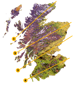
We sampled surface soil horizons in 1990 across four transects that follow the main geological features of Scotland. We can therefore compare remote areas with those closer to urban and industrial centers. The sites (click flashing points for details) seen here on the land cover of Scotland map were mainly heather moorland. Different pollutants were measured and are shown in the accompanying maps (see menu bar on lefthand side of screen). Different spatial distributions were found for different pollutants but in general they all showed similar North-South trends. Although higher levels were found in the Southern Uplands and Central Valley it is important to stress that the levels found are not likely to cause harm. Taken as indicators the pollutant levels show the 'pollution climate' across the Scottish mainland. The sites have been revisited in 1999 and are currently being analysed to determine if any changes have occurred.
| 1 | North Scotland | 3 | Central Valley |
|---|---|---|---|
| 2 | Central Highlands | 4 | Southern Uplands |